Dehmolla, an Ancient Village
Dehmolla is a village in Iran’s Khuzestan province near the cities Mahshahr, Hendijan and Omidiyeh located at latitude 49.40' N and longitude 30.30' E and lies next to the river Zohreh
The population of Dehmolla is approximately 1100, with over 231 houses. Most people in the community are farmers and they grow wheat, watermelon, plum and other fruits
Dehmolla’s antiquity dates back to the Sassanian era, approximately 1500 years ago. In that era Dehmolla named Hendijan and later on it’s name became Hendijan e Bala. It had specific magnitude and has been a transit place for caravans which have came from Arjan(Behbahan) and Asak(an ancient city) toward Persian gulf and IRAQ.
Approximately 1078 years ago (929 AD) Abudolaf describes in his travel itinerary a village named Hendijan, which lies between Asak and Arjan. There is very unique and historic structure in this village that has been dug for ancient trove like that found in Egypt. It is believed that a group of Indians has traveled to this area and began a war with the Iranians. The Iranians who were the victors named this region Hendigan or Hendijan, meaning the place of Indians Hendi meaning Indians in Persian
Professor Minorosky (London University) has written in his book : "ancient Hendijan isn't same to modern Hendijan because modern Hendijan is 20 mile beyond delta of zohreh river .and he add :Abudolaf has stoped your travel in this place And ancient Hendijan is Dehmolla and northern areas of it
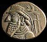
Ahmad Eghtedari, author of the book ‘Geography of Khuzestan’ Kohkiloyeh and Mamassani traveled to Dehmolla in 1977. He describes an ancient place with olden tombs that housed ancient coins and stone coffins. Eghtedar goes on to say that he has seen a place called "Tole Mordo" on the outskirts of Dehmolla and there is a muddy castle called "Borj". This structure has many rooms and 2 stratums and has been built on a hill over an area of approximately 200 by 400 meters. This castle dates back to the Ghajariyeh era (120 years ago
Dehmolla’s ancient sites are named Tole Mordo, Tole Borji, Shabolghasom, Tole Mazemon and the castle in between the village, named BORJ
You can now see the map of Khuzestan dating back 48 years when Dehmolla was mapped which was then wrote Dehi Mulla.it has been specified by green color
 |
Special Thanks to: Pirouz Adhami and Ali Matori for edition